|
 |
|
| City &
Highlight Sightseeing ::
Mashhad ::
Highlights |
|
|
|
MASHHAD'S MOST
VISITED SITES. |
|
|
 |
|
Where to Eat & Drink
in Shiraz
Restaurants & Teahouses
Always try a new local cuisines , you never
forget it. |
|
|
|
Vital Information
Money , Getting
around, internet, Health, Post, Visa,
Safety...etc
A few things to know before getting there |
|
|
|
|
|
|
MASHAD SPECIALS: |
|
|
|
|
 |
 |
 |
| |
|
|
| |
|
|
 Birjand stands in the
southeast of the province,
and is 1309 km. from
Tehran. Being surrounded
by the desert (Kavir) the
weather in the southern
regions is warm and in
mountains it is temperate.
In the past, Birjand was a
small part of a region named
Qahestan (mountain side)
and bore an important role
after Islam prevailed.
Birjand stands in the
southeast of the province,
and is 1309 km. from
Tehran. Being surrounded
by the desert (Kavir) the
weather in the southern
regions is warm and in
mountains it is temperate.
In the past, Birjand was a
small part of a region named
Qahestan (mountain side)
and bore an important role
after Islam prevailed. |
|
This region offered refuge
to some movements such as
the Esmailaian, and on the
other hand proved to shelter
the Arabs who were escaping
from the hands of the Abbasi
Caliphate. In Birjand
evidence of Zoroastrian
vestiges have been
discovered. From the 11th
century AH on wards, during
the Safavid era when the
Shiite religion was formally
recognized, the city
developed economically and
was an important center for
trade and commerce. In
present times Birjand enjoys
its role as one of the focal
cities in the south of the
province of
Khorassan. |
| |
|
|
|
Bojnurd is about 701 km.
from
Tehran and is located in
the plains enjoying a mild
and mountainous weather.
This city was originally
called "Bijan Gerd". Gerd
meaning city and Bojnurd
means Bijans city. The
ancient city was situated on
a hill northwest of the
present city of Bojnurd,
known as Sareban Mahaleh.
The ethnic composition of
Bojnurd comprises of Turk
and Kurd tribes. |
| |
|
|
|
Chenaran lies between the
Binalood Heights in the
south and Radkan Mountains
in the north. Its climate is
cold and mountainous. The
history of this city is
intermingled with that of
Mashad. |
| |
|
|
|
Daregaz is located in the
north of the province of
Khorassan and is 910 km.
from
Tehran. It has a
relatively tropical climate,
and being adjacent to the
borders of Iran and
Turkmenistan it holds an
important military position.
Historical evidences here
are from the Afsharieh era.
The city of Kalat was
occupied and plundered by
Amir Teimoor at the end of
the 8th century AH.
Thereafter Nader Shah took
advantage of conditions and
Kalat was renamed
Kalat-e-Nadery. After the
death of Nader Shah Klat was
governed by a successor who
claimed to be one of the
government of Iran. Daregaz
toDay is one of the most
flourishing cities of the
province. |
| |
|
|
|
Esfarayen is located in the
north west of the province
and is about 772 km. from
Tehran. A part of this
town is situated on the
slopes of Shah Jahan
Mountains and the other part
in the plains. The town
experiences cold weather.
Esfarayen was one of the
focal points where the Aryan
tribes settled after
entering Iran during the
Parthian period. Esfarayen
was then one of the
important villages of
Nayshabur. |
|
Even after the Arabs gained
control, Esfarayen
flourished and continued to
be so after Islam. In spite
of attacks, it was
reconstructed. In the late
8th century AH, this city
was ruined during the
Teimoorian attack. During
the Safavid era the town was
attacked by the Ozbek
tribes. In the Afshar period
the old city of Esfarayen
was completely destroyed
thereby compelling the
inhabitants to reside in the
present city of Esfarayen,
or as it came to be known. |
| |
|
|
|
Fariman came under one of
the townships of
Mashad in the near past.
Fariman is renowned for its
sugar factory which has been
recently reconstructed. |
| |
|
|
|
This city lies on he slopes
of the Kalat mountains. The
salt desert is situated to
the west and north of
Ferdows and has a changeable
climate. In ancient times it
was called Toom and was
founded in the pre-Islamic
era. Ferdows lies 1,158 km.
from
Tehran and toDay is a
thriving city. |
| |
|
|
|
Gonabad is a town located in
the plains some 1,091 km.
from
Tehran. Mountain ranges
stretch from the west to the
east of this land. The city
enjoys a warm climate.
Gonabad is one of the
ancient cities of Iran, the
building of which dates back
to the Achaemenian era. This
city was a center of
conflicts between the
Safavid and Ozbekans, when
the Safavid first came to
power. In the beginning of
the 13th century AH, the
Sheibani tribe, opponent to
the Qajars, seized the
place. So Gonabad suffered
severe destruction but was
reconstructed later. The
historical sites prevailing
date back to the 7th century
AH. |
| |
|
|
|
Kashmar is situated west of
the province of
Khorassan and lies 926
km. from
Tehran. The river Sish
Taraz which flows by Kashmar
has the famous historical
Shahi Dyke spanning its
waters . Due to influences
of the desert the southern
part of Kashmar is warm, and
in the northern areas a
temperate climate prevails.
In older times Kashmar was
known as "Torshiz". In the
year 520 AH, the city was
plundered by Sultan Sanjar
Saljuqi, after which it
became an important centre
of the Esmailieh sect. After
their defeat the city
thrived again, only to be
ruined by Amir Teymour
Goorkani. Historical
monuments of the region date
back to the 7th and 8th
century AH. |
| |
|
|
|
Khaaf is one of the towns
located east of this
province and its natural
landscape consists of
mountains and plains. The
Khaaf Plain is subject to
the 120 Day Sistan winds.
The history of Khaaf mingles
with that of
Torbat Heydarieh and
historical monuments exist
from the 7th century AH. |
| |
|
|
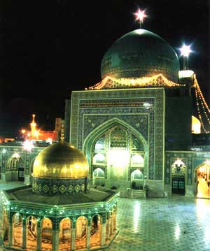
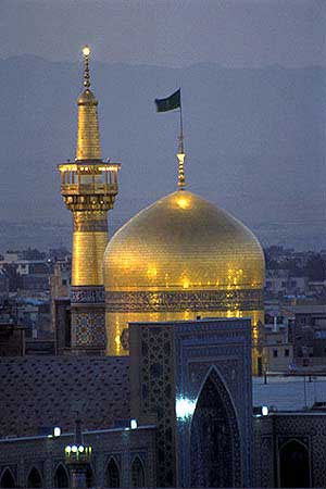
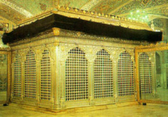
 The city of Mashad is
situated 909 km. from
Tehran in a plain
between the two mountain
ranges of
Binalood and
Hezar Masjed. Mashad
enjoys a temperate,
mountainous climate. In the
year 202 AH, after the
martyrdom of
Imam Reza (AS) in a
place around Toos called
Sanabad which came to be
known as Mashad-e-Reza
(Place of Martyrdom) the
main nucleus of today or
the present Mashad came into
existance. Sultan Mahmood
Qaznavi built a mausoleum on
the shrine.
The city of Mashad is
situated 909 km. from
Tehran in a plain
between the two mountain
ranges of
Binalood and
Hezar Masjed. Mashad
enjoys a temperate,
mountainous climate. In the
year 202 AH, after the
martyrdom of
Imam Reza (AS) in a
place around Toos called
Sanabad which came to be
known as Mashad-e-Reza
(Place of Martyrdom) the
main nucleus of today or
the present Mashad came into
existance. Sultan Mahmood
Qaznavi built a mausoleum on
the shrine. |
|
Due to the destruction of
the city of Toos in the 7th
century AH, people flocked
to the city of Mashad. At
first, the area of Toos was
inhabited by non-Aryans and
some parts of it was
conquered by the Arabs
during the reign of the
Caliph Osman. It was annexed
to the Islamic territory in
the time of Caliph Omar. The
city of Toos was one of the
first to be plundered and
destroyed like the other
cities of
Khorassan by the
Mongols. |
|
The city of Toos due to its
delicate and sensitive
position was subject to
upheavals during the
Teymourian and Ilkhanan
period. Being passed
through, hand to hand
between different
governments, people were
massacred. Ultimately in the
year 807 AH, Shahrokh, the
son of Amir Teymour ascended
the throne and since then
Toos has developed and
thrived, and from the second
half of the 9th century AH,
it came to stand as a suburb
of Mashad. Ruins of the old
city of Toos have come to
remain. But the present Day
Toos has guarded its
importance due to the fact
that the tomb of the great
Iranian poet
Ferdowsi is located
there. |
|
However, toDay Mashad has a
unbreakable link with the
history of ancient Toos and
annually hosts thousands of
pilgrims and visitors and is
one of the focal points of
pilgrims for the Shiite. |
| |
|
|
|
The city of Nayshabur lies
in a level plain and is 768
km. from
Tehran. The
Binalood heights are to
the north, and other heights
run northwest of the city.
The railroad of Tehran -
Mashad passes through
Nayshabur. In the year 31
AH, it was seized by the
Ottomans (Osmani) and during
the Islamic era held its own
as one of the four important
cities in the province. The
city was so vast that it was
called Omol-Belad (mother of
cities). |
|
In the Islamic period, this
city was of such importance
that on their minted coins
the names of the Omavi
Caliphate could be noted.
During the reign of the
Qaznavian and Saljuqian,
Nayshabur was one of the
most important cities of
Khorassan. In the year (618
AH) Nayshabur was destroyed
during the Mongol attack and
it was close to Mongol reign
that Nayshabur was annexed
to the territory of the
Sarbedaran rulers. This city
has played an important role
in attributing to the fields
of Iranian art, civilization
and philosophy. Moreover
this city had a position in
the path or route of the
Silk Road besides many
historical sites. |
| |
|
|
|
Qaenat (Qahestan region) or
Koohestan (mountainside) is
surrounded by the desert
from the south of
Nayshabur right till
Sistan. It has a semi-arid
and temperate climate. Marco
Polo in his records has
named this city as
Tonokayn- the combined
version of the two large
cities of this state i.e.
Toonand Qaen. |
| |
|
|
|
Quchan is located in the
north of the province and in
the neighborhood of the
Republic of Turkeministan.
Due to its strategic
position it controls
commercial traffic in the
way of custom regulations as
well as passengers within
its common border with the
Republic of Turkeministan. |
|
The Aladaq and
Hezar Masjed heights
bear influence on its
climate, such that it has
moderate summers and cold
winters. In the medieval
ages, Quchan was known as
Khabooshan and Khoojan. This
city was rebuilt during the
time of Holakookhan. In
order to prevent the Ozbak
and Torkeman attacks to this
vicinity, Shah Abbas I
transferred the Kurd
warriors to the region. In
the year 1160 AH, Nader Shah
was killed in a place called
Tappeh Nader or (Naders
Hill), close to the city.
Historical remnants date
back to 6th century AH here. |
| |
|
|
|
Sabzevar comprises of two
sections - one part in the
plains which experiences a
warm climate and the other
in the mountainous regions
which enjoys a temperate
climate. This city is
located 654 km. from
Tehran. In the Islamic
era this region was known as
the "Bayhaq" state, which
had two cities called
Sabzevar and Khosrowgerd.
This city was completely
destroyed during the Mongol
rampage. In the year 737 AH
Sabzevar gave refuge to the
Sarbedaran movement, won a
name of Darolmomenin and
became the capital city.
During the attack of the
Ozbeks, this city was
destroyed, but once again
regained development during
the Safavid era. In the last
decade Sabzevar has
flourished considerably. |
| |
|
|
|
Sarakhs is situated in the
far northeastern part of
Khorassan province.
Being under the influence of
the Qaraqom Sandy region it
experiences cold winters and
dry-warm summers. Its
ancient history dates back
to the Sassanian period.
During the Mongol attack in
the year 617 AH, Sarakhs was
plundered and destroyed.
Nearing the end of the Qajar
period, Sarakhs was governed
by a feudal system. It was
also attacked by the
Turkemens. This city in the
past housed many libraries
and was on the path of the
Silk Road. |
| |
|
|
|
Shirvan is 773 km. from
Tehran. In its northern
parts Shirvan experiences
cold weather being a
mountainous region. But the
southern part enjoys a
temperate climate due to the
flow of Atrak River here.
Existence of ancient burial
sites or graves of the
Zoroastrians prove that this
place was inhabited before
the Islamic era and it was
in the year 31 AH that the
inhabitants embraced Islam
during the Caliphate of
Osman. |
|
Though Shirvan flourished
during the Kharazm Shahian
reign it was heavily damaged
under the attacks of the
Goorkanians. In order to
prevent the Ozbak attacks,
Kurd tribes were moved to
this area during the reign
of Shah Abbas I. During the
Qajar period, this place was
a focal point for local
clashes. But in recent years
the city of Shirvan has been
reconstructed according to
modern styles of
architecture. |
| |
|
|
|
Tabas lies in a desert like
terrain to the northwest of
the province. In the higher
regions it experiences a
temperate climate, whereas
in the plains it is hot.
Tabas is 1,345 km. from
Tehran. It has been
subjected to upheavals and
attacks such as the Ottomans
and then was occupied by the
Esmailieh (a religious
sect). During the reign of
the Saljuqian, the Esmailieh
fortresses were attacked. In
the time of Shah Abbas I
this city was ruined by the
Ozbaks. Many of the
historical features
remaining there relate to
the 5th and 9th century AH. |
| |
|
|
|
Taibad is composed of two
sections - one in the plains
and the other in mountainous
regions. Taibad has an arid
to semi-arid and dry
climate, though in its
southern areas the winters
are cold and summers are
temperate. Taibad is so
called because of its
attribution to cleanliness
and goodness. |
| |
|
|
|
The city of
Torbat-e-Haydarieh is
located on the mountain
slopes and has variable
weather in various parts.
This city is 1005 km. from
Tehran. In the ancient
times this city was called
Zaveh, and according to a
narrator in the 7th century
AH, Sheikh Haydar a famous
Gnostic resided there.
Thereby the changes of name
from Zaveh to
Torbat-e-Heydarieh being
related to the lie and
resting place (tomb) of this
great man. Cultural and
historical evidences in this
area relate to the Sassanian
era 7th century AH. |
| |
|
|
|
Torbat-e-Jaam is located 996
km. from
Tehran, and is situated
on the plains having a
temperate mountainous
climate. Its present name is
after a learned personality
known as Sheikh Jaam who is
buried here. There are many
historical evidences in this
region from the 8th and 9th
century AH. |
|
|
|
|
|
|
 |
 |
 |
|
|
|
|
|
|
|
| Suggest your comments about nearby Sightseeing |
Private and group tours Tours , also Accommodation reservation services are available at www.PersiaTours.com for further information , please contact us.
Use the following keywords to find this page online:
Mashhad, Travel Iran Mashhad , Iran Mashhad vacations, Iran
Mashhad tourism, Iran
Mashhad hotels, deals, Iran Mashhad historical travel tour, Iran
Mashhad visitors
guide, Iran Mashhad advice, Iran Mashhad map, Iran Mashhad pictures, Iran
Mashhad
information, Iran Mashhad ratings, Iran Mashhad reviews, Iran
Mashhad airport, Iran
Mashhad weather, Iran Mashhad things to do, Iran
Mashhad attractions, Iran Mashhad cultural tours iran
, Iran Mashhad travel to Iran, Iran Mashhad Iran tours, Iran Mashhad Iran touring,
Iran Mashhad Iran tourism, Tour to Iran Mashhad , Tours in Iran Mashhad , Iran
Mashhad
tour operator, Adventure tours in Iran Mashhad , Business Travel to Iran Mashhad ,
Business Trip to Iran, Archaeology tour in Iran Mashhad , Pilgrim tours in Iran
Mashhad , Persian tours Iran Mashhad , cultural tours in Iran
Mashhad , geographical
tours in Iran Mashhad , Persia, tour to Persia, Trekking tours in Iran
Mashhad , hunting tours in Iran , historical tours
in Iran , climbing tours in Iran Iran Mashhad |
|
|
|
|
|
 |
|