|
 |
|
| City &
Highlight Sightseeing ::
Ahvaz |
|
|
Where To Stay
in Ahvaz
Hotels &
Guesthouses
|
|
 |
|
Where to Eat & Drink
in Ahvaz
Restaurants & Teahouses
Always try a new local cuisines , you never
forget it. |
|
|
|
Vital Information
Money , Getting
around, internet, Health, Post, Visa,
Safety...etc
A few things to know before getting there |
|
|
|
|
|
|
AHWAZ SPECIALS: |
|
|
|
|
 |
 |
 |
| |
|
|
Historical Monuments |
Temples
Ancient Cities and Archaeological
Hills
Castles and Forts
Palaces and Edifices
Inscriptions and Epigraphs
Tombs
Historical Bridges, Caravansaries
and Gorges
Old and Historical Houses
Old Bazaars
Mills
Historical Caves
Historical Graveyards
Other Historical Monuments |
Temples |
|
Bard Neshandeh Temple, Masjed
Soleiman |
|
Bard
Neshandeh is one of the places of
worship in ancient Iran where
religious rituals were held in an
open area. The structure of this
relic belongs to the Parsee and
Achaemenian periods, while the
embossment works on stones dates
back to the Parthian era. The statue
of "Heraclitus" or "Hercules", with
the height of more than 2 m. was
excavated from this temple. This
vicinity consists of three
distinctly separated areas, i.e.,
the palace, a worship place of to
the east of the palace and the
residential areas placed to the
north.
Valuable and historical relics have
been discovered here, these are
displayed and kept in local and
museums abroad. The most important
of these vestiges are, ancient
statues, coins and earthenware.
Back to top
|
|
Choqazanbil Temple (Ziggurat),
Shoosh |
|
Choqazanbil is situated at a
distance of 45 km. south east of
Shoosh, and is the only remnant
of an ancient city, that was
constructed approximately in 1300
B.C. This city which was at the
vicinity of 2 km. from Dez River was
known as "Ontashgal". The same is a
reminder of the new Elamit
civilization. It was surrounded by
three interconnected sun brick made
ramparts with the main entrance
situated in the eastern side of the
largest rampart.
The palaces and tombs of the Elamit
monarchs are situated between the
first and second ramparts. Between
the second and the third ramparts,
the remnants of the water supply and
purification system for city is
observed. The water purification
system of Choqazanbil was to provide
drinking water for citizens, and is
obviously accounted as one of the
most ancient water supply systems.
In the center of the third rampart,
the main temple (Ziggurat) is
placed. This square shaped structure
is constructed at the dimensions of
105x105 sq.m., along four main
directions.
This temple was constructed by means
of millions of bricks, in five
floors. At present only two floors
have been remained. Except for the
first and fifth floors, the rest
have been filled with sun baked
bricks. The fifth floor which is
considered to be the highest one was
used to be the place where idols
were kept. The main idol was called
"Inshushinak" which was considered
to be the most famous deity of
Shoosh city. On the brick walls of
the temple, same inscriptions
designating the name of the king in
the Cuneiform script can be observed
which reveals the aim of the monarch
in the construction of this temple.
Near the temple, on the main ground
there are two circular platforms.
Some believe this to be a place
where sacrifices were carried out,
and the other version is that, this
was an area for astrology.
The aggregate of this city along
with Elamit civilization in the
vicinity of Haft Tappeh, was
demolished in 640 B.C. as a result
of Assyrian conquests, under the
command of 'Ashur Banipal', thence
terminating the Elamit jurisdiction
after a period of more than a
millennium.
Back to top
|
Ancient Cities and Archaeological
Hills |
|
Arjan Ancient City, Behbahan |
|
The
ancient city of Arjan is situated at
a distance of 10 km. north of
Behbahan. ToDay, only hillocks
from this city have remained which
belong to the Sassanid period.
Previously, this city used to have
six gates which were named as,
Ahvaz, Ray Shahr, Maidan,
Kialin, Shiraz and
Eazeh. The Hoomeh or Homayoon
hill is the largest one in Arjan
city.
The residential palace of Shah that
toDay only the ruins of which have
been remained and is reputed as
"Saraye Malek", is located to the
southeast of Arjan city. Due to an
unknown condition this city was
demolished, and the current
Behbahan city has been formed at
its vicinity.
Back to top
|
|
Barmi (Barmak) Hills, Ramhormoz |
|
This
hill lies to the south of
Ramhormoz, near the village of
Keymeh. In this hillock unscientific
and illegal excavations have taken
place. Articles such as statues of
animals, designed earthenware etc.
have also been discovered.
Back to top
|
|
Behgovar City (Effects of Teshoon
Plain), Behbahan |
|
To
the west of the
Behbahan plains, amidst the
small and scattered meadows, there
are the ruins of 'Behgovad' or
'Behgovaz'city which was used to
extend 20 sq.km. in area.
Back to top
|
|
Choqamish Hill, Dezful |
|
Within a distance of 40 km. south
east of
Dezful a few clay hills have
remained which are known as
Choqamish. According to various
studies and research work, it is
believed that Choqamish Hill dates
back to pre invention of calligraphy
to about 34 centuries B.C.
The primitive culture of its
inhabitants has been verified by
means of their special method clay
modeling and beautifully designed
earthenware. This culture dates back
to about 6000 years B.C.
Back to top
|
|
Dastova Ancient City, Shooshtar |
|
The
ancient city of Dastova is located 3
km. south of
Shooshtar, alongside the
Dariyoon stream. According to
evidences, Dastova city was
constructed during the Parthian rule
by 'Shilhak Inshushinak'. But in the
early Islamic era, this city became
deserted and forlorn. The writer of
the book 'Al Ansab' has mentioned
the name of Dastova as, "A city in
Khuzestan", from which Dastova
textiles have come.
Back to top
|
|
Gotvand Village, Shooshtar |
|
Gotvand, is the center of the
Gotvand district in
Shooshtar. The
Karoon River flows from north to
south of the same, and the Gotvand
Dam has been constructed in the
north upon this river. This region
experiences a moderate and dry
climate, and the most important
religious vestiges here are, the
Elamit Ziggurat temple, Rostam
Castle, Moqam Ali, and the Shah
Soleiman and Peer Ahmad Mausoleums.
Back to top
|
|
Jondi Shapour Ancient City, Dezful |
|
The
ancient city of Jondi Shapour lies
at a distance of 10 km. from
Dezful, at the vicinity of Shah
Abad village.
There is a strong possibility that
Shahpour I was responsible for the
construction of this city after his
victory over Valerian. His
descendant (7th generation) known as
'Shapour Zol Akhtaf', developed and
expanded the city to a large one.
Its university in its own time was
of great repute throughout the
world, and even in the last decades
has been considered to be a great
scientific center.
Back to top
|
|
Kolgah Zarri Hill, Masjed Soleiman |
|
The
ancient hill of Kolgah Zarri is
situated to the south of
Masjed Soleiman city, in the
vicinity of "Kolgah" region. This
monument dates back to 3rd
millennium B.C.
An engraving inscription about the
Prophet Abraham (P.B.U.H), reveals
the adherence of its inhabitants to
the religion of this prophet at that
time. This inscription is 6 m. in
length and 4 m. in breadth which has
been sculptured on a huge rock. In
this area, relics from the Sassanid
and Parthian periods have also been
discovered, and during the
Achaemenian age it was also
considered vital.
Back to top
|
|
Shoosh Hills (Shahr-e-Shahi), Shoosh |
|
The
eastern vicinity of the
Shoosh hillocks is known as
Shahr-e-Shahi. Numerous relics have
been discovered here, relative to
the Elamit, Achaemenian, Parthian,
and Sassanid periods. Besides which
the remnants of roads, passages and
dwellings have also been discovered
here. The discovered relics,
instruments, tools and skulls
reveals that the native inhabitants
of this territory before migration
of the Aryans had been scattered and
dwelled in southern and central
territories of Iran and established
the Elamit rules and governments.
The method of constructions, burial
of dead bodies, placing a stove in
the center of room, etc., are
examples of general life-style and
other rituals of these people.
Back to top
|
|
Other Ancient Cities and
Archaeological Hills, Khuzestan |
|
The
Sassani Shami village in
Eazeh, the Shahr-e-Sassani in
Andimeshk, the ruins of
Mokhtarak city in
Ramhormoz, the ancient city of
Asak (Kalat) in Hindijan and Salihak
village in
Behbahan. The other ancient an
archaeological hills of
Khuzestan province are, Haft
Tappeh, Shoosh Hillocks
(Shahr-e-San'atgaran) in
Shoosh, Sood or Razini Hillock
in
Ramhormoz, and the ancient
hillocks of Kalgir in
Masjed
Soleiman.
Back to top
|
Castles
and Forts |
|
Acropol
(Shoosh) Castle, Shoosh |
|
The
Acropol or
Shoosh castle was constructed by
a group of French archeologists in
the year 1897 A.D. in the highest
region of the city. The same is very
similar to the Bastille in France.
This castle has been constructed by
Dezful artists and by means of
bricks obtained from Darius Castle
and some engraved bricks in the
Kufic script from
Choqazanbil. This castle was in
the hands of the French authorities
before the Islamic revolution, after
which it was utilized as the
archeological center of Shoosh.
Valuable and important relics such
as the famous statue of Queen
Napirasustoon, Hamurabi Code and
famed buff earthenware glass of
Shoosh with a wild goat drawing have
been discovered from the Acropol
Hill. It took a period of 15 years
to build this structure which stood
as a defense fort against the attack
of local clans and tribes. During
Iran-Iraq war this castle was under
the bombardment of Iraqi troops, and
later on came under re-construction
and repair.
Back to top
|
|
Arjan Castle, Behbahan |
|
The
Arjan Castle in
Behbahan Township has been
constructed at the top of Sanglakh
Mountain stuck to a colossal slab of
stone. Rain water was used to be
collected in water reservoirs of
this castle through this slab of
stone. The structural architecture
of towers is of roman style, i.e.,
cubic in shape. The castle has a
comparatively large courtyard, with
chambers in three floors having
roman styled ceilings.
Back to top
|
|
Bardi Castle, Masjed Soleiman |
|
This
castle is accounted as the first
permanent settlement place for
Parsee tribes, as well as the
birthplace of Cyrus the Achaemenian.
It is located in the Andika sector
of
Masjed Soleiman. The Bardi
castle is a huge structure which was
built during the Elamit period and
made of large slabs of stones
(without mortar). At present the
untouched walls of the castle have
been remained.
Back to top
|
|
Dokhtar Castle, Ramhormoz |
|
This
castle is located to the north of
Ramhormoz. The spherical
structure denotes the style of Roman
architecture. This castle was most
probably constructed in the Sassanid
reign for protection and safety of
commercial, trade and military route
between Shoosh, Vajar and Esfahan.
Another theory is that the same was
used to guard the treasury and
palace of Ramhormoz, and Romans also
participated in building this
structure.
Back to top
|
|
Rostam Gotvand Castle, Shooshtar |
|
This
castle is located to the north of
Gotvand Village and was erected on
the top of a hillock. The walls
which have been constructed by
cobbled stone with a mixture of
gypsum and ... have been remained.
In the past, this castle was used
for military purposes, and among
local people it was known as Rostam
Palace or Prison.
Back to top
|
|
Simband (Taqa) Castle, Masjed
Soleiman |
|
The
same is a little tower or turret
with one room, located on a hill in
a part of Andika in
Masjed Soleiman. It was in this
vicinity that the Elamit captured a
number of Anzanis or (Bakhtiyari
Tribes), and imprisoned them. From
this point of view it is of great
historical value.
Back to top
|
|
Yazdgerd (Tashary) Castle, Ramhormoz |
|
This
castle is located near the village
of Shurdin, in the township of
Ramhormoz. Close to this
vicinity is a rocky castle called
'Zard Bordiyeh', which has large and
small crevices similar to
pre-historic shelters. Besides which
there are other numerous remnants
such as, shelters of stone,
dwellings, rooms, streets, troughs
and a temple. Circular shaped
castles are constructed on a
foundation, and a water supply
system can still be observed here.
Back to top
|
|
Other Castles and Forts, Khuzestan |
|
These
are named as: The Shahpur Sassanid
Castle, Salasel, the Rostam Aqili
Castle in
Shooshtar, the Tol Castle in
Andimeshk, the Tork Dez Castle in
Masjed Soleiman, the Khajeh
Castle, Leit (Reyt) castle in Andika
of Masjed Soleiman, the Dizeh Varaz
Castle of Faramarz-e-Ashkani, the
Ark or Arkh Castle, Qolla Golab, Gel
va Dah Mard to the east of Sardasht,
the Ancient Castle of Baba Saif to
the east of the Hindijan road.
Back to top
|
Palaces and Edifices |
|
Apadana (Darius) Palace, Shoosh |
|
This
palace was constructed by the order
of Darius the Achaemenian on the top
of Elamit hillocks and is known as
Darius (Apadana) Palace. The walls
of the palace are made of sun baked
bricks with a brick worked facade,
and the pillars are of stone.
Apadana Palace consists of a
pavilion, haramsara (a section for
court ladies), gateway,
entertainment hall and three central
courtyards. The internal walls of
the palace are adorned with engraved
glazed bricks depicting the
winged-lion guard soldiers and
adorned by lotus flowers, the
remnants of which are on display in
local museums and those in abroad. A
major portion of this palace caught
on fire during the reign of Ardeshir
I, (461 B.C.), and finally during
the conquests of Alexander, the said
palace along with other Achaemenian
palaces were completely ruined.
Back to top
|
|
Ivan-e-Karkheh Palace, Shoosh |
|
This
is a monument from the Sassanid
period and is located 20 km.
northwest of the ruined city of
Shoosh. It is known as 'Kut
Karkheh' or Ivan-e-Kharkheh Palace.
A colossal rampart encloses the
palace, and on each side there are
entrances at regular intervals. To
the east of the area, there is a
ruined structure out of which only
an arched ceiling made of brick has
been remained. Previously it was
supposed to be a spectacular
glorious hall used for formal
ceremonies of the court of Sassanid
monarchs.
Back to top
|
|
Sefeh-ye Sar Masjed, Masjed Soleiman |
|
On
the top of a hillock over looking a
locality named "Sar Masjed", relics
of a palace or temple has remained
which dates back to the 7th century
B.C. Irregular polished rock stones,
broken round pillars as well as
arched ceilings are scattered in
this area.
Back to top
|
|
Shaoor (Ardeshir) Palace, Shoosh |
|
The
remnants of this palace are situated
along the western banks of the
Shaoor River, opposite the mausoleum
of the Prophet Danial (P.B.U.H).
This palace has a square shaped hall
with lateral installations. The
columns or pillars are made of
stone, and its walls are of sun
baked bricks. This palace was
constructed during the reign of
Ardeshir II, and was used as his
residential palace as well as a seat
of power.
Back to top
|
Inscriptions and Epigraphs |
|
Bard Engraving, Eazeh |
|
In
the Bard Nebeshteh Valley there is
an irregular piece of stone present
alongside the mountain. They are
carved by excellent skilled
artisans. The carvings show a tall
man with abundant hair and a round
cap, with a sword in his hand. To
his right hand is a rider, and to
his left a few human figures can
also be observed.
Back to top
|
|
Koobad Engraving, Eazeh |
This
engraving is carved on a rectangular
rock with the dimension of 3x1.5
sq.m. in area. This tablet denotes
five human figures with long robes,
and with their hands on their
chests. In front of these five
people there is a figure of a man or
woman with long robe, sitting on a
platform and gazing at the other
five figures. The local inhabitants
believe that this epigraph
designates a school.
Back to top
|
|
Kool Farah Engraving, Eazeh |
|
The
same is situated at the end of
Eazeh plains, and on its own way
is an astonishing one. This
engraving depicts the figure heads
of the monarch, commander, men,
women, captives and beasts such as
cows, bison and sheep. It shows a
form of worship or respect and the
offering of gifts to the ruler. This
engraving belongs to the Elamit seat
of power before the birth of Christ,
and accounts for one of the
important and ancient evidences of
the
Khuzestan Province.
Back to top
|
|
Tang-e-Sorook (Soolok) Engraving,
Behbahan |
The said
engravings are 50 km. North West of
Behbahan and are related to the
Parthian period.
Back to top
|
|
Tang-e-Takab Inscriptions, Behbahan |
The same is
located at a distance of 9 km. north
of
Behbahan. Not far from the
entrance of the gorge, there are a
few inscriptions in simple Nasta'liq
script engraved on rocks. The first
inscription is four-sided and
reveals the endeavors of the
Behbahan governor (ruler) during the
reign of Naseredin Shah. The other
inscription is triangular in shape
and designates the method of
cultivation of the lotus flower in
the outskirts of the city and a few
other areas.
Back to top
|
|
Other Inscriptions and Engravingss,
Khuzestan |
|
Other
epigraphs or engravings in the
province are named as, Jong-e-Ajdal
or Ajdar, Sossan's statue and the
inscriptions of Hani in
Eazeh, belong to the Elamit era.
Back to top
|
Tombs |
|
Bara'-ebne Malek Tomb, Shooshtar |
|
The
same lies to the north of
Shooshtar. It is opposite the
Salasel Castle, and is one of the
oldest tombs of the Islamic period
in Iran. Bara'-ebne-Malek Ansari was
one of the disciples of the Prophet
Mohammad (P.B.U.H). Bara'-ebne-Malek
was martyred during the conquest of
Shooshtar in the year 17 or 18 A.H.
by Hormozan the ruler of
Khuzestan.
Within the mausoleum is a wooden
painted sepulcher with a simple
grave. The main chamber of the
mausoleum is in the upper section,
on which a circular structure is
erected. Inside the mausoleum and
the internal dome is constructed
according to the Safavid
architecture. The external facade of
mausoleum displays a fine piece of
plaster work and paintings. It is
adorned by beautiful tile works and
inscriptions. Eight windows with
roman style crescent shaped arches
have been placed at regular
intervals between the inscriptions.
Back to top
|
|
Haft Shahidan Mausoleum, Masjed
Soleiman |
|
This
mausoleum is in the midst of the
Haft Shahidan Village graveyard. It
has a tile worked dome with sacred
versus of "Ya Allah", "Ya Mohammad"
and "Ya Ali" inscribed around it.
These effects and the original
structure of the mausoleum are from
the Qajar period.
The mausoleum has a square courtyard
with porches and chambers around it.
To the exterior side of the
structure an inscription worked in
black and white tiles has been
affixed to the portal. This
mausoleum is the tomb of the seven
Sadats or those being the
descendants of the Prophet Mohammed.
The architecture of main structure
belongs to the Qajar period.
Back to top
|
|
Khezr Mausoleum, Shooshtar |
|
This
mausoleum is situated in
Shooshtar, and comprises of two
court-yards, the mausoleum and its
porches. Upon a red colored stone
arch the date of 762 A.H. can be
observed. The mausoleum in the lower
section is tetragonal while at the
upper section is octagonal. The
ceilings under the dome have four
conical apertures according to
Saljuqi architecture. In the other
court-yard is a mausoleum with a
small door, an octagonal dome and
beautiful plaster work of the
Saljuqi era. On the ceilings of one
of the porches there is a poem
written on plaster with beautiful
calligraphy on which the date of
1248 A.H. is seen.
Back to top
|
|
Saheb-ol Zaman Cemetery, Shooshtar |
|
The
said mausoleum stands to the east of
Dezful, and comprises of the
sepulcher, porches and two storied
buildings. On the structure is a
twelve paneled dome. The mode of
architecture of the under dome
structure relates to the 9th century
A.H. The southern entrance has a
stairway which was used by the
elite, and is adorned with arches.
The original structure of the
mausoleum was constructed during the
Teimoorid period. It has been
mentioned in records that this
mausoleum is the resting abode of a
descendant of the seventh Imam of
the Shiite sect, i.e., fourteen
generations later.
Back to top
|
Historical Bridges, Caravansaries
and Gorges |
|
Ab-e-Shoor (Av-e-soor) Bridge,
Dezful |
|
The
remnants of this ancient Sassanid
Bridge are located on one of the
branches of the
Karoon River in the city of
Dezful. The lofty and strong
foundation of this bridge is a
stunning sight. This bridge was
built under the orders of Lady
Kharaza, the mother of Ardeshir
Babakan.
Back to top
|
|
Dezful Caravansary, Dezful |
|
In
the city of
Dezful, remnant of some
semi-ruined caravansaries which most
probably belong to Safavid era and
the rule of "Vakhashtu Khan" exist.
There are two ancient caravansaries
that are Nowadays used by traders
and salesmen. They are known as
Afzal and Qandi caravansaries.
Back to top
|
|
Dezful Old Bridge, Dezful |
|
The
old
Dezful Bridge was constructed
during the Sassanid era, and
accounts for one of the ancient
bridges in the world. At present
this bridge connects Dezful and
Andimeshk cities. It has been
repaired several times during the
reign of Azedodowleh Daylami, the
Safavid, Qajar and early Pahlavi
periods. The bridge currently has
four large arches, and between every
two of these is a smaller arch. Near
the bridge, remnants of ancient
mills can be observed.
Back to top
|
|
Karkheh River Bridge, Dehloran Road,
Shoosh |
|
This
bridge is also known as the old
Karkheh Bridge or Naderi Bridge. It
is located in Dehloran Road, to the
north of the new steel bridge. The
ancient bridge was constructed of
stone, mortar and slabs of
sculptured stone. The remnants of
which are an arch and a pillar.
There is a link between this bridge
and the relics of
Ivan-e-Karkheh Palace, thence of
high historical and tourism value.
Back to top
|
|
Kasra Bridge, Behbahan |
|
This
bridge is a relic of Sassanid
period, and was constructed on the
Taab River en route from
Behbahan to Imamzadeh Ja'far.
Nowadays in summer, with depression
of water surface level of the river,
the remnants of this bridge can be
observed.
Back to top
|
|
Pol-e-Dokhtar Arjan Bridge, Behbahan |
|
There
are remnants of a bridge and dam on
Taab River in the district of Arjan
of
Behbahan Township. It is similar
to the great bridge of
Shooshtar, but in smaller
dimensions. To the south corner,
there are evidences of four pillars
and a part of dam. To the north
corner of this relic are also the
remnants of four wells dug in stones
along with a water supply system.
Back to top
|
|
Saolak Gorge, Masjed Soleiman |
|
The
Saolak Gorge lies in the central
portion of the
Masjed Soleiman Township. In
this gorge there are drawings of a
goddess or a Magus (Magi), in front
of whom fifteen people lined up in
two rows. They have conical caps
with abundant hair. There is also
another drawing in this vicinity
depicting a rider armed with a bow
and arrow, and battling against a
beast resembling a bear. This effect
is related to the Parthian period.
Back to top
|
|
Shadravan Bridge, Shooshtar |
|
The
Shadravan Bridge runs parallel to
the newly constructed bridge located
on the
Shooshtar -
Dezful Road. This ancient bridge
is a relic of Sassanid period
(Shahpour I). One of the conditions
that Kaiser of Rome and his soldiers
could be set free was the
construction of Shadravan Bridge,
and this condition was agreed to by
the emperor. When the construction
of bridge was finished, Shapour
released the order to set free the
Kaiser of Rome and his soldiers and
they returned back to their country.
Sixteen arches of this bridge have
remained. The Shadravan Bridge has
been built of cobbled stone and
mortar.
Back to top
|
|
Shooshtar Caravansaries, Shooshtar |
|
In
the past the customs office of
Khuzestan was located in
Shooshtar city, thus prompting
the establishment of caravansaries
in this area. Of which the Hashemi
and Abrisham Kari Caravansaries
located in the center of the city
are worth mentioning. The atmosphere
of these caravansaries is suitable
for traditional tea houses and
restaurants.
Back to top
|
|
Tak Ab Gorge, Behbahan |
|
The
Tak Ab Gorge is located 20 km.
northeast of
Behbahan, and is also known as
'Darband-e-Pars'. In the natural
terrain of this gorge, parts of the
gravel walk or flagstones (for the
royalty) from the Achaemenian era
have been remained. On the top of
Khaviz Mountain and at the highest
point of gorge, there are two
engravings of prose and poetry from
the Qajar period. There had also
been another epigraph consisting of
seven lines in the 'Kufic' script
which was unfortunately destroyed in
explosion for the construction of
the Maroon Dam.
Back to top
|
|
Other Old Bridges, Khuzestan |
|
The
rest of the old bridges of the
Khuzestan Province are as
follows: The Lashkar Bridge, the
Sassanid Band Gerger Bridge in
Shooshtar, the Haj Khodaie,
Sassanid or Arjan Bridges and
Bandbekan Bridges in
Behbahan, the Negin and Bard
Qomchi Bridges in Andika of
Masjed Soleiman, the Safavid
Nafas Kesh or the Shah Ali Bridge in
Shooshtar.
Back to top
|
Old and Historical Houses |
|
Moeinol Tojar House, Shooshtar |
|
In
'Dar-e-Abbas' locality of
Shooshtar, there is a
comparatively old house that till
the year 1970 was utilized as a
school (the Ardeshir School). The
peripheral stone and plaster work of
windows are spectacularly
interesting which display the
delicate craftsmanship of the Qajar
period.
Back to top
|
|
Mostowfi House, Shooshtar |
|
This
edifice is related to the late Qajar
period. From its garden the Shateit
River and its surroundings can be
observed. The walls and ceilings of
this house have been decorated by
brick work. Its large shabestan
(nocturnal praying area) has fine
and beautiful brick made pillars.
This house will be converted into a
museum, in order to display vestiges
discovered in
Shooshtar.
Back to top
|
|
Other Old Houses, Khuzestan |
|
Other
old houses in the province are named
as, The Haj Mon'em, Amin-ol-Tojar
(Amin Zadeh), Afzal and Douraqi
houses in
Shooshtar.
Back to top
|
Old Bazaars
|
|
Shooshtar Bazaar, Shooshtar |
|
The
ancient bazaar of
Shooshtar is known as
Qeisariyeh. Construction of this
bazaar dates back to the times when
Kaiser of Rome was captive in the
hands of Shahpour Sassanid. Its
architectural structure is cross
shaped. It is a covered bazaar with
some sutures for the passage of
light. In the past, each of the six
gateways of the city terminated to
bazaar and city center. In 1950 this
bazaar was demolished due to main
street construction in the city. The
present name of this street is
"Taleqani", in which the new, as
well as Qeisariyeh Bazaars are
located.
Back to top
|
Mills |
|
Ra'na and Golegah Old Mills, Dezful |
|
This
vestige is located in the west of
Dezful, alongside the Dez River.
Around this place various roman
arches, walls made of stone and
mortar along with large and small
chambers in a state of ruin and can
be observed. The Golegah Mills
situated at a distance of 300 m.
from the Balarood Dam, and is a
relic of the Sassanid era.
Back to top
|
|
Sika Water Mills, Shooshtar |
|
One
of the oldest and most beautiful
structures of
Shooshtar is the Sika Water
Mills. It is an area with small
rooms and narrow corridors,
alongside which streams of water
canals are observed. It has outlets
to the Gerger River. In these mills
the high pressure of water current
from up to down, move the wheels for
grinding the wheat. In summers a
pleasant drizzling wind blowing in
the Sika rooms which creates a cool
recreational place for people of
Shooshtar.
Back to top
|
Historical Caves |
|
Eshkoft Salman Cave, Eazeh |
|
The
same is located at a distance of 3
km. from the current city of
Eazeh. Eshkoft Salman is a cave
within a natural rock, which has a
spring with clear and sweet water
that extrudes out through another
smaller and narrower cave. To the
right and opposite the Eshkoft
Salman, there are two embossed
profiles within two square engraved
hollow surfaces.
A lighted brazier is displayed in
front of them that reaches their
knees. To the east of these two
profiles, there is a large crevice
over which the mountain has been
curved, and formed a shelter. Below
this, on surface of the mountain
there is a rectangular epigraph with
the Cuneiform script and a few
engravings. Under this inscription,
which is placed at high level, is a
seat or throne. There is a
possibility that this could also be
an area for performing special
rituals.
Back to top
|
|
Kohnab (Eshkoft Kohnab) Cave, Masjed
Soleiman |
|
This
cave extends from Tang Anbar-e-Sefid
Lali, (in the district of Lali) in
Masjed Soleiman and terminates
in the vicinity of Cholvar. This
area is an interesting site
regarding the archeological studies
as well as for sight seeing.
Back to top
|
Historical Graveyards |
|
Sassanid Hormoz Grave, Ramhormoz |
|
This
tomb or grave is located in one of
main streets of
Ramhormoz city in the midst of a
garden. According to the statement
of people, this tomb belongs to
Hormoz Sassanid, the founder of
Ramhormoz city. Within a short
distance is the tomb of Imamzadeh
Bibi Seeni, which is a place of
pilgrimage that may remind us of
Bibi Sassanid.
Back to top
|
|
Shami Graveyard, Eazeh |
|
The
same is located in Shami village,
north of
Eazeh. In this vicinity a large
number of tombs resembling those
belonging to the Sassanid period are
observed. Unfortunately they have
been illegally excavated. Relics and
statues discovered in this area,
speak of a much older civilization.
Back to top
|
|
Zoroastrian Graveyard, Ahvaz |
|
In
the eastern mountainous region of
Ahvaz, there are some engraved
crypts right in the heart of
mountain, which was supposed to be
the burial place for Zoroastrians of
Ahvaz in the pre-Islamic era. The
present appearance and condition of
crypts reveals that these places
probably used to be temples, and
later on became a burial place or
graveyard.
Back to top
|
Other Historical Monuments |
|
Kheraf Khaneh, Shooshtar |
|
Kheraf Khaneh comprises of a series
of crypts which have been made
within the rocks on the outskirts of
the city. There is a strong
possibility that these crypts used
to belong to Zoroastrians of the
Medes and Parthian eras. According
to public opinion, when in past the
families were unable to take care of
their elders, they used to keep them
in these crypts, bringing them food
and water at intervals of few day
so that they spent the rest of their
lives there, till death.
Back to top
|
|
Other Historical Monuments,
Khuzestan |
|
These
are called, Tow Ashiqoon (Ottaq-e-Ashiqan)
and Kolah Farangi in
Shooshtar,
Taq-e-Nosrat-e-Sassani and Hormoz
Sassani Tomb in
Ramhormoz.
Back to top
|
| |
|
|
|
 |
 |
 |
|
|
|
|
| |
|
|
Religious
Monuments |
Old Mosques
Mausoleums and Imamzadehs |
Old Mosques |
|
Dezful Jame' Mosque, Dezful |
|
The
Jame' Mosque of
Dezful is situated in the
central square of the city and is a
remnant of the 3rd or 4th century
A.H. The same has been repeatedly
undergone repairs in 7th, 9th and
11th and recent centuries A.H.,
which has resulted in its expansion.
The structure of the mosque
comprises of the main entrance,
porches, a vast courtyard and
nocturnal areas (Shabestans) to the
south and east.
The mosque has four small entrances,
three of which are blocked. The
North West facade is a remnant of
the 12th century A.H. and is adorned
with arches and tile works. The main
part of the current mosque is its
pillared nocturnal area to the
south. The ceiling and brick dome of
this Shabestan is erected on stone
pillars. The eastern porch is a
construction of the Safavid era,
while the nocturnal area of the
mosque is its oldest segment. On the
northern and western side walls of
the mosque the dates of 13th and
14th centuries A.H. have been
designated.
Back to top
|
|
Molla Ali Shah Mosque, Dezful |
|
This
mosque is near the chamber of Aqa
Mir in
Dezful. Its entrance had tile
works, the pattern of which has been
disrupted in later repairs. The
fringes of the adytum have been
worked in a spiral design, and the
internal pattern is plaster work
which relates to the Safavid era.
The fringe of adytum is ornamented
by flower, wheat and cypress tree
designs.
Back to top
|
|
Shoosh Mosque, Shoosh |
|
The
remnants of this structure are
located on the ancient
Shoosh hillock. This mosque
consisted of a nocturnal area, with
column, a central courtyard and an
outer enclosure. The walls were made
of sun baked bricks. It also had a
large pillared hall, and brick
worked inscriptions in the Kufic
script and were discovered from the
south eastern part of the courtyard.
To the eastern corner of the mosque
there is the remnant of a minaret
with a spiral stairway. Professor
Grishman believes that this mosque
belongs to the first century A.H.
Back to top
|
|
Shooshtar Jame' Mosque, Shooshtar |
|
This
mosque is located in west of
Shooshtar, and is a remnant of
the early Islamic period. It was
constructed by one of the Abbassid
caliphates. The same was repaired
during the Safavid era. The current
structure of the mosque comprises of
a large nocturnal area (shabestan),
a vast court-yard and minarets to
the east. The nocturnal area has
pillars and is covered with a domed
ceiling. In the middle of southern
side of the nocturnal area is an
adytum with plaster works of Safavid
style. On the other side
inscriptions and plaster engravings
along with decrees of royalty can
also be noted.
On the external doorway to this
area, which is adorned with arches
and decorative brick works there are
two inscriptions on stone with
sacred versus of the Holy Qoran. In
the eastern side of the mosque is a
remnant of a beautiful minaret
dating back to the 8th century A.H.,
which is intricately worked and
inscribed with sacred versus of
"Allah", "Mohammad", "Ali". This
minaret has been repaired recently,
and is registered on records.
Back to top
|
|
Other Old Mosques, Khuzestan |
|
Other
ancient mosques of
Khuzestan province are, Bokan
Jame' Mosque in
Behbahan, a relic of the first
century A.H. The Sheikh Mosque in
Shooshtar, the Lab Khandan and
the Bazar-e-Kohneh Mosques in
Dezful, the Imamzadeh Heydar and
Omar Mosques in Behbahan, the Sheikh
Esmail and Sheikh Mo'azi Mosques in
Dezful, the Hassan Shooshtar, Sultan
Mehrab, Shah Safi, Seyed Naseredin,
Seyed Mohammad Mahro and Hossain
Mosques in Shooshtar.
Back to top
|
Mausoleums and Imamzadehs |
|
Danial-e-Nabi Mausoleum, Shoosh |
|
The
same is located on the eastern banks
of the Shoor River. This mausoleum
is the resting abode of one of the
prophets of the Israelites. This
mausoleum has two courtyards, which
are surrounded with chambers and
porches. The mausoleum is located at
the end of the second courtyard,
which has rooms in three side of
courtyard for a nights stay of
pilgrims.
In this mausoleum, the sepulcher
below the tomb is an old yellow
colored stone devoid of any
inscriptions. The ceiling of the
mausoleum has beautiful mirror works
with light apertures on eight sides
under the dome. The foundations of
the mausoleum are old but thick and
strong. The upper section of eastern
side of mausoleum is adorned with
tile works. The dome of
Danial-e-Nabi is a multi-sided,
hexagonal in shape erected on a
circular base.
Back to top
|
|
Imamzadeh Abdollah, Shooshtar |
|
This
tomb is located on an elevation in
the south of
Shooshtar, around which is an
old cemetery. Its stone entrance is
related to the Safavid era. The tall
portal has two minarets on either
side and these are adorned with tile
work.
This Imamzadeh also has a quaint
wooden door which dates to 1035 A.H.
Its domed ceiling is adorned with
flower patterns related to the Qajar
period, and its brass sepulcher is a
relic from the reign of Naseredin
Shah Qajar. The current structure of
the mausoleum is the effect of Mehdi
Ali Khan, the governor of Shooshtar
during the reign of Shah Abbas
Safavid in the year 1002 A.H. The
said Imamzadeh is related to the
fourth Imam of the Shiite sect.
Back to top
|
|
Imamzadeh Shah Mir Ali Hossein,
Behbahan |
The said is
situated to the south of
Behbahan. The portal leading to
the area of the tomb, has three
inscriptions on each side. In the
older section are inscriptions
dating 1053 A.H. coinciding with the
reign of Shah Abbas Safavid II.
Back to top
|
|
Other Mausoleums and Imamzadehs,
Khuzestan |
Other ancient
Imamzadehs in the province are,
Imamzadeh Abazar in
Behbahan, Imamzadeh Seyed Hassan
in
Shooshtar, Imam Reza Deymi
Mausoleum in Shooshtar, Abu Danial
Mausoleum in
Dezful, Peer Ishaq Masuloeum in
Haft Tappeh of Dezful, Peer Roban
Mausoleum in Dezful, Seyed Mohammad
Giahkhar, Seyed Mohammad Mahro and
Shah Abol Hassan/Shah Mard
Mausoleums in Shooshtar, Shah Abol
Qasem Mausoleum in
Masjed Soleiman, Abbas Ali/Abbas
Azim Mausoleum in Dezful, Baba Zeid
Gilani Mausoleum in Masjed Soleiman,
Imamzadeh Shahsavar Ibrahim in
Eazeh, Imamzadehs Aqa Barakat
and Anbar and Sa'dat Lali in Masjed
Soleiman, Seyed Hassan Zahidan
Mausoleum in
Ramhormoz and Peer Shoja'
Mausoleum in
Shoosh, etc.
Back to top
|
|
|
|
|
|
|
|
|
|
|
|
|
|
| |
|
|
Natural
Attractions |
Rivers
Lakes, Dams and Wetlands
Protected Zones
Springs
Forests and Valleys
Mountain and Summits
|
Rivers |
|
Arvand
Rood River, Khorram Shahr |
|
The
Arvand Rood River flows in the
townships of
Khorram Shahr,
Abadan and to the west of the
Minoo Island, as well as on the
borders of Iran and Iraq. This river
is known as the Shat-ol-Arab in Iraq
and has been formed by meeting two
rivers of Tigris and Euphrates.
These join at a place called Qarneh,
110 km. southwest of Abadan and flow
alongside the city of Basra.
After following a long course, and
flowing through Khorram Shahr and
Abadan, it ultimately reaches the
Persian Gulf. In this river shipping
is possible and the surrounding area
is furthermore an interesting sight.
Back to top
|
|
Jarahi River,
Behbahan |
|
The
Jarahi River flows through the
townships of Kohkiluyeh va Boyer
Ahmad,
Behbahan,
Ramhormoz and
Mah Shahr. It originates from
the mountains of Rah Barik, Sefid
and Golgilak, 53 km. northwest of
Yasooj. After following a long
course, and joining to various
rivers, under the name of Maroon,
enters the township of Behbahan and
then Agajari village.
This river after crossing south of
the Ramhormoz Township and Ramsheer
city, with the name of the Jarahi
River, enters the township of Mah
Shahr and finally flows into the
Persian Gulf.
Back to top
|
|
Karkheh
River, Khuzestan |
|
The
Karkheh River, is the third widest
river in Iran after the
Karoon and Sefid Rood Rivers. It
originates from watersheds of
southeast Kermanshah, and after
flowing a long distance and
adjoining other tributaries under
the name of "Qarah Soo" River along
its course intermingles with "Tang
Kenesht" and "Gamasiyab" Rivers, and
gushing through the valley between
"Galleh" and "Kooh Sefid" Mountains
in the west, flows towards the
south. At this point, it joins the
"Gashani" River, and forms Seimareh
River.
Seimareh River enters Khorram Abad
after flowing a long distance and
adjoining various rivers. The
Seimareh River crosses the "Shir
Qoreh", "Howl","Qal'eh Sam" and
"Papeleh" Mountains and enters the
Province of Ilam. Over here at first
it adjoins the "Chardavol" River and
after crossing a narrow and zigzag
valley of "Kooh Gavar" and "Lareh"
Mountains, diverts towards the
south. Thereafter, it passes by many
rural areas, and after adjoining a
number of rivers, it intermingles
with the Ab-e-Fath River. Through
the territory of "Qallah Sooreh"
gains access to the Sorkheh village
in the township of
Dezful. On crossing the
"Sorkheh-e-Naderi", it enters a wide
area, and a branch of it under the
name of "Shavoor" segregates and
flows towards the city of
Shoosh.
The main river of Kharkheh, on
joining the Roofayeh River, passes
by Shoosh at a distance of 2 km.,
and after crossing a region called
"Lahyozar", 36 km. northwest of
Ahvaz, diverges towards the
southwest. Where it flows alongside
the Hamidiyeh city and enters the
rural areas of
Dasht-e-Azadegan Township.
Thereafter it enters "Dabestan" area
and dividing into various branches
it enters"Hoor-ol-Azim". It
overflows in the rainy seasons and
terminates to the Tigris River. The
course of this river right from the
beginning to the end is astonishing
and interesting.
Back to top
|
|
Karoon River,
Khuzestan |
|
The
Karoon River, is one of the longest
and most saturated rivers of Iran.
It originates from the springs
present in the skirts of the Vank
and Zard Kooh Mountains in the
village of Shurab, 91 km. from
Shahr-e- Kord. With the name of
Ab-e-Koohrang, it flows along the
western valley of the Zard Kooh
Mountains towards the south west.
Entering into the Koohrang Dam Lake,
a part of the water is channeled
through a tunnel in the mountains,
to the source of the Zayandeh Rood
River, and another part, crosses the
dam, and after following a long
distance in the western valley of
the Zard Kooh Mountains, and before
entering
Khuzestan, joins the Khersan
River.
After which it flows through a part
of the village of Mian Kooh and
leaves the Province of Chahar Mahal
va Bakhtiyari and enters the
Khuzestan Province. At this
point a few minor tributaries join
it, and continues in a north eastern
direction entering the village of
Sosan, and the eastern valley of the
Lander Mountains making its way to
the northern valley of the Gozir
Mountains after following a long and
meandering course. On continuation
of its course, the Karoon is joined
by various tributaries, at 8 km.
North West of
Shooshtar it joins the Shoor
River and after crossing this
vicinity, it divides into two.
The western branch after joining the
Huram River, rejoins the said in
Qir. It is at this point that it
intermingles with the Dez River (the
most important and largest branch of
Karoon river), and continuing a long
course it flows towards
Ahvaz. On entering
Khorram Shahr, to the east, it
divides into two. The western branch
called Bahman Sheer flows towards
south west and through Khormosi
reaches the Persian Gulf. The
eastern branch in the south of
Khorram Shahr enters the
Arvand Rood River. Just like the
Karkheh River, Karoon also
follows a spectacular interesting
course.
Back to top
|
|
Zohreh River, Behbahan |
|
The
Zohreh River is flown in the
townships of Mamasani (Fars
Province),
Behbahan, Gachsaran and
Mah Shahr. Its length is 490 km.
and its height from the source is
2,850 m. This river originates from
northwest of Ardakan, and passing a
long course, enters the townships of
Mamasani and Gachsaran under the
name of Zohreh River.
After flowing through the township
of Behbahan, it joins the Kheir Abad
River, and finally at 36 km. to the
southwest of Hindijan, flows into
the Persian Gulf. The surrounding
mountains, valleys, farms and
gardens en route are wonderful and
interesting.
Back to top
|
|
Other Rivers, Khuzestan |
|
These
rivers are as follows: Khur, Nahr
Bahreh, Nahr Gahi and Shahur in the
township of
Ahvaz; Ab-e-Sar-e-Howz, Ab
Sosan, Ab Shalla, Abol Abbas, A'lla,
Seidoon, Ab Sosan and Morq Ab in the
township of
Eazeh; Ab Beed, Ab Dez, Ab
Zaleki, Ab Cham Choli, Ab Sorkh, Ab
Mamak, Ab Meereh, Sorkhab, Rufayeh,
Golal Lab Sefid, Golal Moort, Leus,
Bakhtiari, Shurlali and Golal in
Dezful; Abol Fares, Ab Dareh
Naj, Talkh, Dim Kharkan, Soleimani,
Gozin, Gopal, Maroon, Sameh, Soordez
Gili, Maleh, Ramhormoz and Lir Ab in
Ramhormoz; Ab Berkeh, Ab Kiaras
and Ab-e-Shoor in
Masjed Soleiman; the
Nahr-e-Shadegan River in
Khorram Shahr.
Back to top
|
Lakes, Dams and Wetlands |
|
Balarood Dam, Dezful
|
|
The
same is a relic from the Sassanid
period and was constructed on the
Dezful River (a tributary of Dez
River). The relic consists of a
large room and two smaller rooms
with their foundation pillars in
water. It is made of stone, brick
and a mixture of gypsum and ash.
Back to top
|
|
Borj-e-Ayar Dam, Shooshtar |
|
This
dam has been constructed on Gerger
River, and is also known as Sabi
Kesh Dam. Borj-e-Ayar was the name
of a vessel which was used to store
jewels and gold. This dam has
constructions and facilities in both
sides of the Gerger River which have
been used for the deviation of
water.
Back to top
|
|
Dez Dam Lake, Dezful
|
|
This
dam is 203 m. in height and is
considered to be the highest dam in
the Middle East and ranks the sixth
highest dam in the world. It is
constructed on Dez River at a
distance of 15 km. to the north of
Dezful city. The lake of this
huge dam provides a great scope for
tourism exploitation and water
sports facilities besides its
beautiful landscape and sight-seeing
areas.
Back to top
|
|
Hoor Mazra'eh Wetland, Dezful |
|
The
Mazra'eh Wetland lies between the
two Dez and
Karkheh Rivers (south of
Dezful) and part of Shavoor
River flows into it. The water
obtained from this vicinity is used
for agricultural purposes by the
inhabitants, mainly the tribal
farmers. A special quality of rice,
known as Hoveyzeh is cultivated
here.
Back to top
|
|
Hoor-ol-Azim Wetland, Sosangerd,
Ahvaz |
|
The
length of this wetland is 100 km.
and its width ranges from 15 to 75
km. It is limited from west by the
Tigris River. Throughout, the Hoor
is covered by reeds. The depth of
the water towards the sides is
shallow while in the center it is
more than 7 m. Special canoes can be
used in this wetland. The nature of
Hoor and specially the surrounding
inhabitants are of anthropological
interest.
Back to top
|
|
Hoor-ol-Doraq Wetland, Shadegan |
|
This
is a comparatively vast wetland
which lies in the south western
territories of
Khuzestan. Crossing
Shadegan, the
Jarahi River adjoins this
wetland. Birds, reeds, papyrus and
salt are found here. A kind of herb
which favors humidity and locally is
known as "Cholan" grows here and is
utilized by the natives of Hoor.
Back to top
|
|
Karkheh Dam, Dezful |
|
This
dam is constructed across the
Karkheh River and ranks as a
deviating dam. The length of the dam
is 192 m. and reaches a height of 9
m. Also, around this lake is a vast
recreational site
Back to top
|
|
Karoon Dam, Masjed Soleiman |
|
This
dam, also known as the Shahid
Abbaspour Dam, is constructed on
Karoon River and located to the
northeast of Masjed Soleiman. The
dam is 200 m. in height and its
crown is 380 m. in length. The lake
forms an excellent area for water
sports and tourism exploitations.
Back to top
|
|
Khalil Khan Dam, Masjed Soleiman |
|
This
old dam is situated in the district
of Lali in the township of
Masjed Soleiman. The same is
constructed on a river formed in the
spring season that flows from the
Imamzadeh Baba Ahmad Pass. The ruins
of this ancient dam are still
present.
Back to top
|
|
Khoda Afarin Dam, Shooshtar |
The said dam
also known as Mahi Bazan Dam, and
has been constructed on Gerger
River. The same is a wonder piece of
Sassanid dam construction, which is
an interesting site to visit.
Back to top
|
|
Mizan (Valerian) Dam, Shooshtar |
|
Mizan
or Shapour Dam is a relic of
Sassanid era and divides the
Karoon River into western and
eastern sections. This dam is
semi-circular in shape with two
diverting arms or prolongations
which deviates a part of the Karoon
water to flow along the eastern
region known as the Gerger River,
and the other along western region
of the city known as Shateit River.
These two water ways in the south of
Shooshtar rejoin again in the
Band-e-Qir region to form the great
Karoon.
After the Borj Ayar Bridge many
waterfalls have been naturally
formed extruding the rocks upon the
Gerger River. It is said that
Valerian the emperor of Rome
constructed this bridge. Materials
used in the construction are various
kinds of stone, and the arch has
been designed in an intricate and
spectacular form. This dam is
approximately 521 m. in length. It
has gone under repair during the
Qajar period. The same is also
reputedly known as the Khaqan Dam.
Back to top
|
|
Shadegan Wetland, Shadegan |
|
Shadegan wetland extends over an
area of 296,000 hectares, and its
surface is covered by great
varieties of vegetations. It creates
a suitable habitat for a number of
migrating waterfowls, which fly to
this area from north Europe, Canada
and Siberia in autumn. In this
wetland there are different fish
varieties which live in salt and
sweet-water. This vicinity is a
habitat and breeding ground for the
'Marbled Teal' in the world, and
rare bird species such as the
'Spotted Curlew' and the 'African
Glossy Ibis', are also found in the
surroundings of this wetland.
Generally speaking, this vicinity
can be accounted as a habitat for
one-third of the animal and herbal
species that are on the verge of
extinction.
Back to top
|
|
Other Lakes and Dams, Khuzestan |
|
Other
historical dams of
Khuzestan Province are, Dara,
Dokhtar, Qir and Khak Dams in
Shooshtar which are relics of the
Sassanid period.
Back to top
|
Protected
Zones |
|
Protected Wildlife Zones, Khuzestan |
|
Besides the natural relief like the
snow capped mountains to the north
and east, and the warm low-lying
plains, the banks of the lakes,
wetlands and the beautiful coastal
area of the Persian Gulf, have all
contributed for creation of wildlife
habitat. Karkheh has been recognized
as one of the four natural areas in
the country which is of great value
regarding the environmental
protection basis.
The wildlife area of Karkheh extends
from the Sorkheh Village, located to
the south of
Andimeshk - Dehloran Road, up to
the Khalaf Village, placed to the
north of Hamidiyeh and
Ahvaz. It is accounted as one of
the most important natural wild life
habitat, and the famous species of
this region is the Iranian reign
deer or yellow deer (Iranian follow
deer). The Karkheh wild life habitat
covers an area of 13,000 hectares.
The animal species of
Khuzestan Province specially
those found in wild life habitat of
Karkheh are named as follows: geese,
heron, duck, francolin, bustard,
dull yellow partridge, partridge,
turtle dove, starling, raven,
leopard, deer, boar, rat, squirrel,
porcupine, wild goat, wild sheep
etc. which are unique in their
combination with environment and
nature.
Back to top
|
Springs |
|
Dehloran Mineral Water Spring,
Andimeshk |
|
This
spring is located at a distance of
120 km. on the
Andimeshk - Dehloran Road. Its
mineral content is of a calcium
bi-carbonate composition and is
useful in the treatment of skin,
joint and rheumatoid disorders.
Back to top
|
|
Ein Khosh Spring, Andimeshk |
|
The
said spring is located at a distance
of 13 km. on the
Andimeshk -
Ahvaz Road. Its mineral content
is of a calcium bi-carbonate
composition. It has therapeutic
effects on rheumatoid and joint
disorders.
Back to top
|
|
Gorab Mineral Water Spring,
Shooshtar |
|
At
the vicinity of
Shooshtar there are a number of
mineral water springs, out of which
the mineral water spring of Gorab
Village is famous. This vicinity was
held sacred. People who have
suffered from any pain used to
gather here. The water is useful for
treating skin diseases, eczema and
infectious wounds. In this area,
crypts from the Elamit period,
earthenware from the third and
second centuries B.C. have been
discovered in the surrounding
hillocks. There is also a tomb known
as Peer Abbas, located here.
Back to top
|
|
Other Springs, Khuzestan |
|
These
are named as, the Si Zangar Spring
in
Shooshtar; the spring of Golgir
in
Masjed Soleiman.
Back to top
|
Forests and Valleys |
|
Forests and Plains, Khuzestan |
|
To
the south and west of
Khuzestan Province there is a
vast plain area which is expanded on
the decaying surface of young
residues belonging to Tertiary
period. Most of these plains have
been made of alluviums of the
Karoon,
Karkheh and
Jarahi Rivers. This plain with a
gradual slope extends towards the
south up to the Persian Gulf. To its
extreme north is
Dezful and to the south there
are flat and low plains formed by
flow and ebbing of the tide.
Due to versatile climate and type of
soil, some regions in Khuzestan are
covered by scanty forests. The skirt
of the Solak Mountain is covered by
large chestnut and wild almond
forests. A large forest is formed in
the Karkheh River banks, which
consists of bushes of large trees.
In the rainy season which is from
early November till mid April a
great variety of vegetation grow. In
humid areas mushrooms, lichens and
moss thrive. In the Bakhtiyari
heights, the vegetation covering is
used for feeding herds. To the north
and northeast the vegetation is in a
steppe form, with fig, wild almonds,
chestnut and oak trees, etc.
Back to top
|
Altitudes and Summits |
|
Bardeh Nakhsh Mountain, Eazeh |
The Bardeh
Nakhsh Mountains reach an elevation
of 2,250 m. and is situated 24 km.
north of
Eazeh.
Back to top
|
|
Doto Mountain, Eazeh
|
|
The
forest mountain of Doto is located
to the southeast of
Eazeh and rises to a height of
approximately 3,170 m. This mountain
joins Mount Kalleh from the south
and Mount Lirab from the north. The
eastern skirts of this mountain join
the Sirab Valley, and its western
skirts adjoin the Seidoon Valley. On
the western skirts, there is a small
lake and spring. The mountain slopes
are covered with forests, and are
considered to be a part of Mongasht
Mountain which is a part of the
Zagross Mountain Ranges.
Back to top
|
|
Eshkeft Deraz Mountain, Behbahan |
|
The
Eshkeft Deraz Mountain lies 34 km.
northwest of
Behbahan with an elevation of
2,330 m. The Qallat River originates
from here. This mountain spans from
the northwest towards southeast and
a part of which is densely covered
with chestnut forests.
Back to top
|
|
Mohreh Mountain, Ramhormoz |
|
The
Mohreh Mountain is located to the
southeast of
Ramhormoz with an elevation of
about 2,849 m. The Talkh River
originates from this place. This
mountain joins Mount Tonbalan from
the northwest, Mount Chadun from the
south and Mount Siyah Kooh from
southeast. It is a part of the Sefid
Kooh Range which belongs to the
Zagross Mountain Ranges. This
densely forested region is on the
borders of Ramhormoz,
Eazeh and Kohkiluyeh townships.
Back to top
|
|
Mongasht (Mangasht) Mountain, Eazeh |
|
A
part of the mountainous region of
Mongasht is located in the township
of
Eazeh which has very high
mountains. It is considered to be
one of the longest semi branches of
the Zagross Mountain Ranges. The
highest peak in this area is 3,613
m. and is located at a distance of
55 km. southeast of Eazeh. The
Hallaijan, Ab Zardak and Seidoon
Rivers originate from the western
skirts, the Lirat and Someh Rivers
originate from southern slopes and
three branches of the Khersan and
Karoon Rivers also originate
from the eastern skirts of this
mountain range. A large portion of
this mountain is covered by dense
forests, and at the end of which a
pool is formed the dimensions of 2.5
x 2.5 m. called 'Bundan'.
Back to top
|
|
Sefidune Mountain, Masjed Soleiman |
|
This
mountain reaches an elevation of
2,776 m. and is situated in the
Andika Village in
Masjed Soleiman. The Talluk,
Poolkool and Ab Shiroon Rivers
originate form the skirts of this
mountain. The Sefidune Mountain is
connected to Mount Zangab from the
north and to Mount Monar from the
southeast.
Back to top
|
|
Shahrood Mountain, Dezful |
|
The
Shahrood Mountain is located in Mian
Kooh Village of
Dezful and is 2,550 m. in
height. The Shahrood and Shast Mahro
Rivers originate from here. This
mountain joins Mount Gooshtoon from
the south and Mount Birenj from the
north.
Back to top
|
|
Other Altitudes and Summits,
Khuzestan |
|
These
are named as: The Tappeh Foolie,
Kharaf Khoon, Khanrireh, Sarbal,
Mishdakh Mountains etc. in
Ahvaz; the Aram, Ahangari,
Badrangan, Chella, Zarin Kooh, Saam,
Gilan, Seh Paran, Soltan Ebrahim
Mountains etc. in
Eazeh; the Band Golal, Paznan,
Sheebkar, Arboon, Qal'eh Ahmad and
Mahmood Mountains etc. in
Behbahan; the Beesheh Bozan,
Kiga, Eskandar-e-Khandan, Pallangan,
Nissarulleh, Noudar, Ab Soor Kalli
Mountains etc. in
Dezful; the Tonballan, Qal'eh
Najaf, Dasht-e-Kallat Mountains etc.
in
Ramhormoz; the Ab Anbar, Pir
Ahmad, Tal, Gach, Golak, Haft
Cheshmeh Mountains etc. in
Shooshtar; the Asmari, Anbar
Asbi, Baba Zahed, Tal-e-Gavi, Chal
Maidan, Gach Narges, Nounar, Abu
Rastan Mountains etc. in
Masjed Soleiman.
Back to top
|
|
|
|
|
|
|
|
|
|
|
|
|
|
| |
|
|
Culture &
Art |
Museums
Handicrafts, Music, and Foods |
Museums |
|
Abadan Museum, Abadan |
|
The
said museum is located in Ahmad Abad
Avenue of
Abadan. It is a single storied
building with a dome similar to that
of the
Danial-e-Nabi Mausoleum. This
museum was inaugurated in 1959 and
was prone to damage during the
imposed Iran - Iraq war. Its relics
are being housed in a safe place for
the time being till repairs are
completed in the museum.
Back to top
|
|
Haft Tappeh Museum, Dezful |
|
The
said is a single storied building,
which was inaugurated in the year
1973. The building has a cement
skeleton with a brick and stone
facade. This museum is equipped with
a library, archive, laboratory and a
printing press. Its relics are
temporarily being safeguarded in
Tehran until repairs to the damages
it suffered during the imposed Iran
- Iraq War are completed.
Back to top
|
|
Shoosh Museum, Shoosh
|
|
The
Shoosh Museum is situated amidst a
garden near the ancient
Shoosh Castle, and opposite the
Danial-e-Nabi Mausoleum. The
construction of this museum
coincided with the excavations at
Shoosh. Thereby the bricks
discovered there and in
Choqazanbil were utilized in
construction of this building. Some
other parts have been also added to
the museum in the following years.
The museum was inaugurated in the
year 1966 and displays remnants from
the pre-Elamit to the Islamic
period. The Shoosh Museum has six
exhibition halls in which all the
vestiges discovered during
excavations made in Shoosh and
Choqazanbil are on display.
Back to top
|
Handicrafts, Music, and Foods |
|
Handicrafts and Souvenirs, Khuzestan |
From the
past, the
Province of Khuzestan was
renounced for its textiles and silk
weaving industry. The ancient Arab
geographer Al Moqaddassi has
mentioned about the textiles of this
area in his records.
Shooshtar and its surroundings
are renounced for its sleeveless
cloaks made of both thick and fine
materials.
Shadegan is also famous for its
cloaks. The weaving of the Islamic
veil and the Arab veil is a dominant
feature here. Bed Sheets of
Shooshtar, waist wrappers of
Dezful, jajeems (a loosely woven
woolen material) of Shadegan are
worth mentioning. Besides there are
other handicrafts such as, carpet, a
kind of chain stitch embroidery,
Gelim weaving (a type of coarse
carpet), Jajeem weaving, mat and
rush mat weaving, bedding wrappers,
manufacture of Warsaw silver and ...
can be taken to account as the
handicrafts of this province.
Back to top
|
|
Local and Regional Foods, Khuzestan
|
|
Food
habits of
Khuzestan people have
intermingled with their occupation
and type of their job.
 Types
of Fish: Fried fish, Mahroot, Saboor,
Fish Khoresht, Sorkhoo Fish,
Masmooteh, Marg Samak, Kooshk Fish,
Vegetable Fish, Fish Soup, Prawn,
Tandori Fish, Shoor Fish, and Kookoo. Types
of Fish: Fried fish, Mahroot, Saboor,
Fish Khoresht, Sorkhoo Fish,
Masmooteh, Marg Samak, Kooshk Fish,
Vegetable Fish, Fish Soup, Prawn,
Tandori Fish, Shoor Fish, and Kookoo.
Types
of Polow: Prawn Polow, Kalam Polow,
Behbahan Polow and Tah Chin.
Types
of Kabab:Zard Kabab and Kabab Shireh.
The Province of Khuzestan has a wide
array of local delicacies such as
Aash Dowa, Kaleh Pacheh, Koofteh
Berenji, Panirak, Baqala, Sa'din,
Hamis Tooleh, Samosa, Siloon Va
Ardeh, Toochiri, Hashow, Doroshteh,
Sholeh Ardeh, Maccaroni with carrot,
Qolqol, Meat Roles, Chalpateh,
Mahbooseh, Meat bread, Dandro,
Hariseh, Omlet, Khoresht Bamiyeh,
Khoresht Shalqam, Nesha', She'riyeh,
Ma'saleh Date, a variety of curries,
local bread and pickles.
Back to top
|
|
Local Music and Dances, Khuzestan
|
|
In
the
Province of Khuzestan Shooshtari
notes played in "Homayoon" musical
division are very famous. Musical
instruments such as "Flute", "Oboe",
"Kettle drum", "Tambourine" and
other instruments are used. Arab
lamentations and poetry such as "Abu
Ziyeh", "Atab", "Abu Tageh" or "Basteh",
etc., have deeply influenced this
territory. The local Arab music
singers are called "Al Khashebeh"
which play Arabic music. There is
another local Arabic song and music
known as "Alvaniyeh". In "Atab"
melody there is some kind of sorrow,
while "Abu Tageh" is a delighting
group song which is normally
accompanied with a group dance
called "Talgat Asba'". Arabic
musical instruments are "Motbag",
"Windpipe", "Al Azabeh", "Drum",
"Tambourine", "Al Zanjari", "Robab",
"Santur" and "Damam".
Back to top
|
| |
|
|
|
|
|
|
|
|
|
|
|
| |
|
|
Townships |
Abadan
Ahvaz
Andimeshk
Baq-e-Malek
Behbahan
Dasht-e-Azadegan
Dezful
Eazeh
Khorram Shahr
Mah Shahr
Masjed Soleiman
Ramhormoz
Shadegan
Shoosh
Shooshtar
|
Abadan |
The township
of Abadan is located to the
southwest of the province, and
experiences short winters and long
warm summers, along with a high
percentage of humidity. Abadan is a
delta shaped island, with its base
facing towards the Persian Gulf and
its head towards
Khorram Shahr. Previously it was
supposed to be called "Khezr Island"
but later on it was known as
"Ebadan". In 1935 "Ebadan" changed
to "Abadan". Its center is the city
of Abadan, which lies at a distance
of 1,000 km. from Tehran.
At the end of the 13th century A.H.,
due to the presence of the oil
industry, Abadan developed and
expanded. In the year 1909, the
refinery factories were erected,
which unfortunately suffered heavy
damage during the imposed war
between Iran and Iraq. After which
it is gradually regaining its former
status. This refinery is one of the
attractive sites of the city of
Abadan, and is one of the oldest and
largest refineries in the world.
Back to top
|
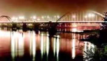
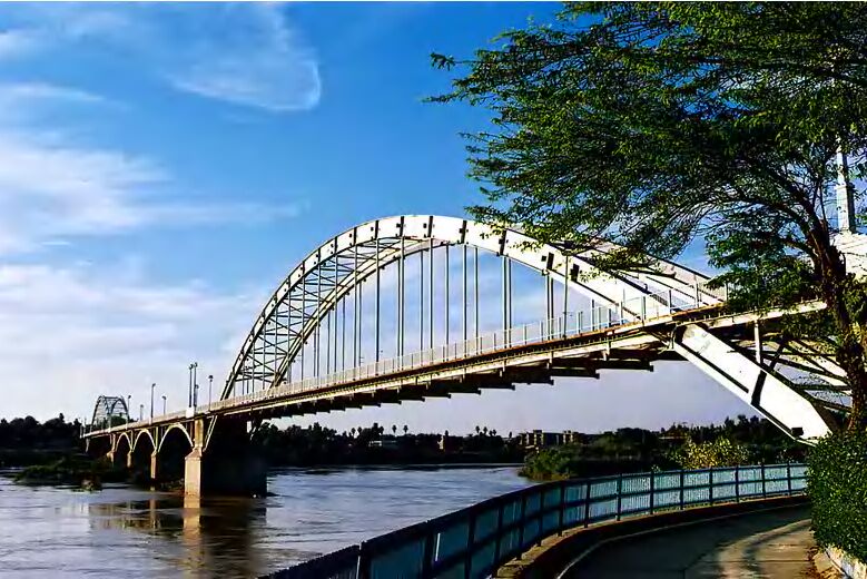
Ahvaz |
|
The
township of Ahvaz is situated in the
central portion of the province and
has a warm and humid climate. Ahvaz
is the center and largest city of
the province and is located 874 km.
from Tehran. In ancient times it was
called "Hormozd Ardeshir" and then
"Soq-ol-Ahvaz". Later on it was
known as "Naseri". Some historians
have mentioned it as "Algeenis".
There is a strong possibility that
the city of Ahvaz is located on the
site of the old city of "Taryana".
Ardeshir Sassanid I rebuilt Taryana
and named it "Hormozd Ardeshir".
During his reign and that of his
successors, the city prospered, and
instead of
Susa became the capital of
"Suziana" (Khuzestan).
At the time that the Arabs gained
control of Suziana, Hormozd Ardeshir
was renamed to Soq-ol-Ahvaz, which
means the market of Khuzis or
Hoories.
During the period of Omavi and
Abbasides Caliphs, Ahvaz city
flourished and became the center for
the cultivation of sugar-cane. But
at the end of the 3rd century A.H.
due to upheavals of Saheb-ol-Zanj it
witnessed a decline. Later on
efforts were put for recapturing its
fame, but in the mid 9th century
A.H., the destruction of its large
dam further more intensified the
decline of the city from the former
position that it was used to enjoy.
The construction of the Suez Canal,
improved trade and shipping on
Karoon River, and reformation of
Bandar-e-Naseri as a port during the
Qajar era, once again caused
flourishing of Ahvaz, and its name
was changed to Naseriyeh. During
Pahlavi period, the city was
re-gained its old name, i.e.,
'Ahvaz'. At present it plays an
important role regarding the
cultural, economical and industrial
fields in Iran as well as being one
of the highly populated areas of the
province.
Back to top
|
Andimeshk
|
|
The
township of Andimeshk is located to
the north of the
Khuzestan Province, on the
southern slopes of Zagross Mountains
and at a distance of 726 km from
Tehran. It has common borders with
Lurestan.
The city of Andimeshk was
constructed near the ruins of the
ancient city of "Lur" (Aritareen).
"Lur" was a flourishing city, and
its name is mentioned in the records
of ancient geographers, i.e.,
Estakhry and Moqadasi. "Lur"
continued flourishing till mid ages,
since then it was demolished and
turned into a ruin. In the Qajar
era, Andimeshk gained further glory
and importance due to construction
of a castle by "Haj Saleh Khan
Mokri", and thereby came to be known
as "Saleh Abad", and thence
Andimeshk.
Back to top
|
Baq-e-Malek
|
|
This
township is situated to the east of
the province, and has common borders
with Kohkiluyeh va Boyer Ahmad
Province. The city of Baq-e-Malek is
located at a distance of 1,024 km.
from Tehran. This vicinity has an
ancient historical background. The
elevated regions, forests, natural
landscapes and rivers have provided
a great opportunity for development
and flourishing of this territory.
Back to top
|
Behbahan
|
|
The
township of Behbahan has a
semi-desert like climate, with hot
scorching summers and rainy winters.
Its center is Behbahan city, which
is located at a distance of 1,105
km. from Tehran. The ruling center
of ancient times was known as "Qobad
Foreh" and "Arkan". Qobad Ebne
Firooz was the first person
responsible for constructing "Arrehjan"
(Behbahan) city.
During the Sassanian era, the city
of Arrehjan which is located at a
distance of 12 km. from the current
city of Behbahan was erected. After
the destruction of Arrehjan city,
the inhabitants flocked to Behbahan.
In the 4th century B.C. the city of
Arrehjan was fully populated, but in
the second half of the 8th century,
not a trace of Arrehjan remained,
and in a short period the current
city of Behbahan replaced the
former.
Back to top
|
Dasht-e-Azadegan |
|
The
said township is situated to the
west of the province and it has a
common border with Iraq. Its center
is Sosangerd which is located at a
distance of 941 km. from Tehran. It
has warm and dry climate.
Originally, Dasht-e-Azadehgan was
known as "Bani Taraf" and in the
year 1935, was changed to
"Dasht-e-Mishan", and thence after
the Islamic revolution, was re-named
as "Dasht-e-Azadegan". The
inhabitants of this vicinity are
Arab tribes.
Till the year 1944, this area was a
part of the
Ahvaz Township. Later on it
joined the Bostan district, and
turned into the township of
Dasht-e-Mishan (Dasht-e-Azadegan).
Back to top
|
Dezful |
|
The
township of Dezful lies at a
distance of 721 km. from Tehran, and
is located to the north of
Khuzestan Province. Generally,
it has a desert like and
comparatively dry weather with hot
summers and moderate winters. The
word Dezful has been derived from
the words 'Dejpol' or 'Despool', and
in local language it is known as
'Dezpeel'. It is said that the
people who constructed the bridge,
erected a fort or "Dej" right at the
beginning of the same to protect the
bridge. Since then the name of
"Dejpol" has remained on this city.
Alike the city of
Shooshtar, Dezful surpassed the
city of Jondishahpur. On destruction
of the latter, Dezful progressed to
a greater extent. Later on due to
the devastating state of its water
network, which was from the Sassanid
period, the city and its
surroundings were subject to heavy
damages. Although, Dezful remained
safe from the Mongol attacks, but
later on came under the Ilkhanan
jurisdiction, and did not show any
resistance against the attacks of
Amir Teimoor.
Nader Shah was responsible for
safeguarding this vicinity against
the Lors, and thereby erected a
castle called Dej Shah a few
kilometers to the northeast of
Behbahan. Presently Dezful is
one of the thriving and important
cities of Khuzestan Province.
Back to top
|
Eazeh |
|
The
township of Eazeh has cold winters
and moderate summers, with the city
of Eazeh as its center. Eazeh lies
at a distance of 1,082 km. from
Tehran. This land was one of the old
centers of civilization, even so
during the Elamit period, and was
considered as one of the prospering
areas. The ancient "Anzan" or
"Anshan" was also located close to
the city of Eazeh.
The Greeks flourished here during
the time of the Selooki or
Seleucidians. Even during the
Sassanian period the old city of
Eazeh existed. During the early
Islamic period, this city proved to
be one of the important cities of
Khuzestan, and had an
independent ruler. In the Attabak
period, the city was called Malmir
(Mal-e-Amir means belonging to
Amir). Later on the name of Eazeh
was completely forgotten, and it was
during the Pahlavi reign that it was
re-focused on. Till the year 1953,
Eazeh was a district of
Ahvaz and it was only in 1958
that it was claimed to be a
township.
Back to top
|
Khorram
Shahr |
|
The
township of Khorram Shahr
experiences extremely hot and humid
weather, and the Port of Khorram
Shahr (Bandar-e-Khorram Shahr), is
located 994 km. from Tehran. In the
12th century A.H., Khorram Shahr was
nothing more than a small village,
and it was only in the beginning of
the 13th century that it changed
into a reputed sea port. It was
under interest due to its strategic
position, and therefore suffered
repeated foreign attacks. The
Ottoman Empire in the year 1883
A.D., Britain in the year 1857 A.D.,
and finally Iraq in the year 1980,
surrounded Khorram Shahr
respectively.
Discovery of oil in 19th century and
proximity to the oil refinery
factory of Abadan frequently added
to its importance. The old name of
Khorram Shahr under the influence of
the red color of the
Karoon River was "Mohammarreh".
During the imposed war of Iraq, this
city suffered heavy damages and
loss, besides being occupied by the
enemy for a period of 575 day,
ultimately regaining its freedom on
May 23, 1982.
Back to top
|
Mah Shahr
|
|
The
township of Mah Shahr lies at a
distance of 1,025 km. from Tehran,
and is located to the south of the
province and along the coast of the
Persian Gulf. It was formerly called
"Bandar-e-Ma'shoor", and even long
before that it was known as
"Mahruyan" and "Machuleh". In the
year 1965, its name was changed to
"Bandar-e-Mah Shahr". The said had
been one of the most important ports
for export of oil from Iran, before
Kharq was facilitated.
ToDay Mah Shahr is the focal point
for export of gas and refinery
products in
Abadan. Most of the citizens of
Mah Shahr mainly have been dwelled
in the old sector of city which is
located at a distance of 3 km. from
the new site.
Back to top
|
Masjed
Soleiman |
|
The
said township is situated to the
north of the province, and has
common borders with Esfahan and
Chahar Mahal va Bakhtiyari
provinces. It accounts for being an
important area as the 'winter
residing quarter' for the Bakhtiyari
Tribes. This township is located in
the mountainous areas as well as the
plains, with moderate winters and
warm summers. Its center is the city
of Masjed Soleiman which lies at a
distance of 1,030 km. from Tehran.
Masjed Soleiman is one of the
important cities of
Khuzestan Province regarding the
oil industry.
According to archeological
discoveries, evidences relative to
the pre-historic ages and cavemen
have been observed here.
Furthermore, it is believed that
Hushang Pishdadi by means of two
flints (stones) discovered fire in
this area. Masjed Soleiman held
importance during the various reigns
such as, the Elamits, Medes,
Parsees, Seleucidians, Parthians and
the Sassanids. This vicinity was the
birthplace of Chish Pesh Parsi. Near
the current city of Masjed Soleiman
is the great fire-temple from the
Parthian and Sassanid periods.
In the ancient times, this area was
known as 'Tolqor', but in 1924 after
the visit of Pahlavi I, and on his
suggestion to the parliament, this
vicinity was assigned Masjed
Soleiman in the year 1926 by
parliament, and toDay is one of the
thriving and industrial cities of
the province.
Back to top
|
Ramhormoz
|
|
The
township of Ramhormoz is situated to
the east of the province and
experiences a warm climate. Its
center is Ramhormoz city, and lies
at a distance of 1,008 km. from
Tehran. It has common border with
the Province of Kohkiluyeh va Boyer
Ahmad. Ramhormoz is a historical
city and the founder is said to be
Hormoz Sassani. Previously it was
known as "Samangan".
In spite of being a historical city,
it remained under developed. The
historical territory of Ramsheer is
in this township, and the ruins of
the ancient site of Ramsheer are at
the vicinity of 3 km. The importance
of Ramshir is more due to existence
of the large bridge of Ramshir,
built on
Jarahi (Maroon) River, which
acts as a link connecting the
southern sea ports with Ramshir
City. In recent years, Ramhormoz has
regained its importance and is
considered to be one of the fast
developing and important townships
of
Khuzestan Province.
Back to top
|
Shadegan
|
|
Shadegan is one of the southern
townships of
Khuzestan Province. Its center
is the city of Shadegan which is
located at 971 km. from Tehran. It
experiences a warm and desert like
climate. The old name of Shadegan
was "Soroq" and its central
government city was known as
"Dowraq". Soroq is one of the
townships of Khuzestan and the name
of a river around which by the order
of Ardeshir, the son of Bahman
Esfandiyar some cities were
excavated. Currently the city of
Shadegan has expanded and is famous
for its woven sleeveless cloaks
(aba).
Back to top
|
Shoosh (Susa)
|
|
The
township of Shoosh is located to the
northwest of the province, and has
common borders with the Ilam
Province. Its center is the city of
Shoosh which is at a distance of
1,010 km. from Tehran. It
experiences a hot climate. Susa is
considered to be one of the oldest
centers of civilization throughout
the globe. In archeological
excavations, relics related to the
pre-historic era have been
discovered here. The Elamits were
the first clans who were responsible
for its flourishment.
During this reign Susa was
proclaimed as a capital. Even after
the Achaemenians gained control over
Susa, the latter sustained its
splendor and was selected as the
winter capital by Darius the
Achaemenid. Till the beginning of
the control by the Muslims, Shoosh
continued to thrive. In the year
1898 A.D., the famous
Castle of Shoosh was constructed
by "Morgan" on the northern part of
the Acropol hill. The ancient name
of Shoosh was 'Soos' or 'Dasht-e-Soosiana',
and later on was changed to Shoosh.
Back to top
|
Shooshtar |
|
The
township of Shooshtar is located at
a distance of 831 km. from Tehran
and has cold winters, but is warm
for the rest of the year. Shooshtar
lies to the north of
Ahvaz. According to the Iranian
mythology, the founder of this city
is supposed to be Hushang Pishdadi.
The conquest of Shooshtar by the
Muslims took place in the Omar
caliphate period. Shooshtar at the
times of Bani Omayeh, was in hands
of "Khavarej" (those who had turned
against religion).
In the year 820 A.H., Amir Teimoor
conquered this area and thereafter
it became the center of the Shiite
sect. In 1165-1167 A.H. Nader Shah
continuously attacked this vicinity
and in these battles many were
killed. During the reign of Fathali
Shah Qajar, the cities of Shooshtar,
Dezful and Hoveyzeh, became a
part of the Kermanshah Province. In
the reign of Mozzafar-edin-Shah,
segregation among the two groups of
"Heydari" and "Ne'mati" increased to
its highest level, and Khaz'al Khan
encouraged the Arabs to assault
Shooshtar. In Pahlavi era, after
repeated unrest, the region
ultimately gained peace, and toDay
is considered to be one of the
important cities of
Khuzestan Province.
Back to top
|
|
. |
|
|
|
|
|
|
|
|
|
|
|
|
|
|
| Suggest your comments about nearby Sightseeing |
Private and group tours Tours , also Accommodation reservation services are available at
www.PersiaTours.com for further information , please contact us.
Use the following keywords to find this page online:Ahvaz,
Travel Ahvaz , Ahvaz vacations, Ahvaz tourism, Ahvaz
hotels, deals, Ahvaz historical travel tour, Ahvaz
visitors guide, Ahvaz advice, Ahvaz map, Ahvaz
pictures, Ahvaz information, Ahvaz ratings, Ahvaz
reviews, Ahvaz airport, Ahvaz weather, Ahvaz things
to do, Ahvaz attractions, Ahvaz cultural tours iran
, Ahvaz travel to Iran, Ahvaz Iran tours, Ahvaz Iran
touring, Ahvaz Iran tourism, Tour to Ahvaz, Tours in
Ahvaz, Ahvaz tour operator, Adventure tours in
Ahvaz, Business Travel to Ahvaz, Business Trip to
Iran, Archaeology tour in Ahvaz, Pilgrim tours in
Ahvaz, Persian tours Ahvaz, cultural tours in Ahvaz,
geographical tours in Ahvaz , Persia, tour to
Persia, Trekking tours in Ahvaz, hunting tours in
Iran , historical tours in Iran , climbing tours in
Iran Ahvaz |
|
|
|
|
|
 |
|